

FAA Increases UAV Nationwide COA Ceiling to 400 Feet
Posted by Matt on 3/29/2016 to
Drones
Today the Federal Aviation Administration (FAA) has announced that the “blanket” altitude authorization of 200 feet for Section 333 exemption holders has been increased to 400 feet. This essentially doubles the approved commercial UAV flight height legally defined by the FAA. While our testing has found that for orthomosaic creation the ideal height for a 12MP camera, like the one on the DJI Phantom 3, is about 200 – 250 feet, this new ruling by the FAA opens things for infrastructure inspections.
Mobile GIS: What to do with a GPS Antenna?
Posted by Matt on 3/17/2016 to
Adopting Mobile GIS
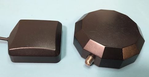
One of the things professionals have to get used to when they switch from submeter handheld GNSS equipment to mobile GIS workflows with submeter GNSS receivers is their antenna. The important thing to keep in mind is the antenna needs to “see” as much sky as possible and preferably at all times. Below we present a few methods for working with the external antennas used with Bluetooth GPS and GNSS receivers.
Arrow GNSS Interface App
Posted by AFS on 3/1/2016 to
Adopting Mobile GIS
At Anatum Field Solutions, our group prides itself on being both agnostic to equipment manufacturers and using this equipment in the field. We don’t do as much field work as we did working as biologists and environmental consultants before we started this company, but we still do a lot of field testing of equipment both independently and with our clients around the United States.
