

DJI's newest Enterprise platform. DJI M350 RTK Vs DJI M300 RTK
Posted by Ryan on 5/19/2023 to
Knowledge Base
On May 18th, 2023, DJI unveiled an upgrade to its flagship Matrice 300 RTK (M300 RTK), via the new Matrice 350 RTK (M350 RTK). We’re going to break down the difference between the M300 and M350.

Making the Earth Flat
Posted by Ryan on 1/17/2023 to
Knowledge Base
One of the most common points of confusion for GIS users comes from understanding the differences between geographic coordinate systems and projected coordinate systems, as well as some of the other geodesy jargon often referenced

Common GPS Terminology and Definitions
Posted by Ryan on 4/21/2022 to
Knowledge Base
List of common GPS and GNSS terms and definitions
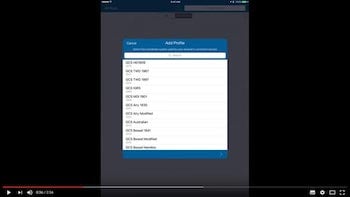
Tutorial Video for Creating RTK Correction Profile in both (new) and Classic Versions of Collector for iOS
Posted by AFS on 1/1/2020 to
Tutorial Videos
This tutorial video walks through the steps for creating a RTK Correction Profile (NAD83 - 2011) for Esri's Collector app on iOS platforms.

GPS Technology Discussion with ArchaeoTech Podcast
Posted by Matt on 6/16/2019 to
Adopting Mobile GIS
Recently I had the pleasure of being a guest on the Archaeology Podcast to discuss today's GNSS technology. Give it a listen to learn more about the current state of GPS and GNSS technology and how it relates to archaeology in the field.
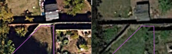
Advanced Mobile Mapping Series: Why Does My GPS Data and Imagery Not Line Up?
Posted by Matt on 6/10/2019 to
Adopting Mobile GIS
Why your GPS data doesn't line up with your aerial imagery is a common question. This article discusses the various reasons for this discrepancy.
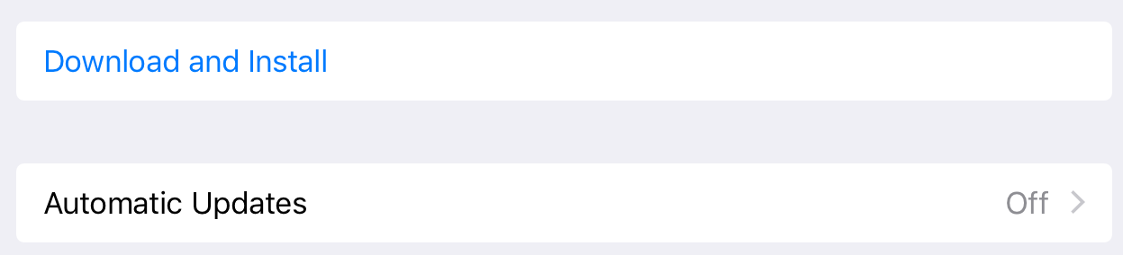
Updating Your Mobile OS: The Double-Edged Sword of Updates
Posted by Matt on 5/10/2019 to
Adopting Mobile GIS
This article is aimed at the question of updating or not updating the OS for your mobile mapping device. Ideally, we could all update our devices used for mobile mapping without worrying about any unforeseen software bugs, but that just isn't the case. There will always be the potential for a software bug to inhibit our ability to collect field data with our mobile device. This article focuses on the best practices for determining when and if to complete an OS or mapping software update.
How Do I Know My GPS Antenna Height?
Posted by Matt on 2/13/2019 to
Knowledge Base
Do you know the exact height of your GPS antenna mounted on your survey pole? Here is how you can tell.
%20small%20-%2013.jpg)
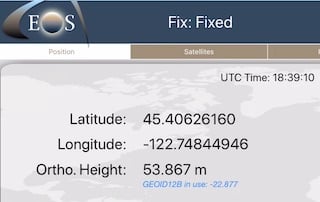
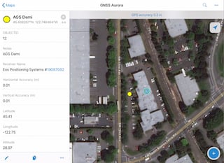
How to Setup Esri's New Collector to Capture Orthometric Heights
Posted by Tyler Gakstatter on 1/22/2019 to
Knowledge Base
This how-to workflow is designed for the New Collector from Esri, formerly known as the Aurora project. This will only capture live Orthometric heights with an Eos Arrow receiver running the Geoid12B in the Eos Tools Pro app. Doing that will allow Collector points to capture real-time NAVD88 elevations.
How to Capture Real-time Orthometric Heights with Esri's Collector
Posted by Matt on 11/26/2018 to
Tutorial Videos
These videos walk users through how to set up and utilize the new Eos Tools Pro ability to apply the Geoid12B model to elevations for live capture in Esri's Collector app.
Sneak Peek at Esri's New Collector Aurora
Posted by Matt on 11/26/2018 to
Tutorial Videos
With Esri set to release its new version of Collector (known as the Aurora project) in late November or early December for iOS devices, we decided to give our clients a sneak peek at Aurora.

Laser Mapping for Esri Collector
Posted by Matt on 8/16/2018 to
Tutorial Videos
If you have been waiting for a solution to do offset mapping and measurement in Collector, it is here! The videos below take you through the full details step-by-step!

The Value of Mobile GIS and the Power of Cloud Computing in Natural Resource Management
Posted by Matt on 7/4/2018 to
Adopting Mobile GIS
Using Mobile GIS equipment and workflows with cloud computing can streamline data collection and management for field staff and allow managers to make more timely and informed land management and conservation decisions. These workflows also greatly increase the efficiency of reporting. Not only can these solutions save man-hours and money, but also reduce potential human errors introduced by recording field data on paper and then having to manually enter that data into a computer database.

Fast Field Work: Collector for ArcGIS and High Accuracy GPS
Posted by Matt on 4/9/2018 to
Adopting Mobile GIS
Sulphur Springs Valley Electric Coop transitions to Moblie GIS with iPads, Arrow Gold RTK receivers, and Esri Collector for ArcGIS to update the location accuracy of more than 34,000 assets in less than two months time! Learn more about how the accomplished this feat.

Everything You Need to Know About GPS for Switching to Mobile GIS
Posted by Matt on 1/15/2018 to
Adopting Mobile GIS
This article will break down the nitty-gritty of today’s GPS equipment and how to use the newest Bluetooth-enabled GPS receivers with your phone or tablet to get the best out of your Mobile GIS field data collection.
It was originally published in the Fall 2017 Volume 10 Issue 1 of BayGeo Journal.
Matt and Esri Co-teach Collector Workshops
Posted by Matt on 6/28/2017 to
Adopting Mobile GIS
Anatum's very own Matt Alexander teaches the technology portion and explains GPS technology and user best practices alongside the Esri staff with their focus on Collector for ArcGIS.
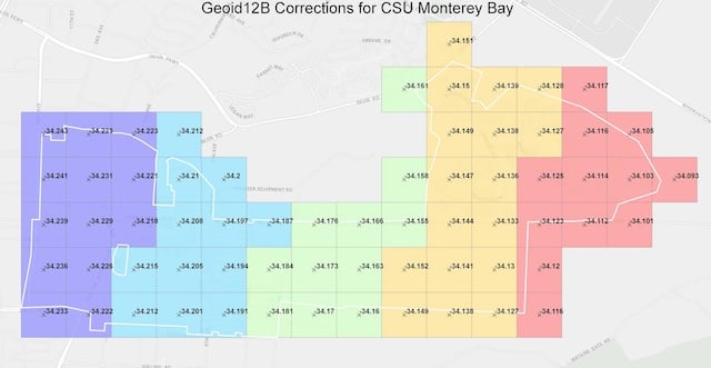
CSU Monterey Bay Tackles High-Accuracy RTK and Elevations with Collector
Posted by Matt on 5/19/2017 to
Adopting Mobile GIS
To capture horizontal (horizontal datum NAD83) and elevational data (vertical datum NAVD88), the university needed to determine first the required accuracy and if there was an affordable technology solution that could accomplish the task. By working with the GNSS experts at Anatum Field Solutions and their review of Bluetooth GNSS options, the EOS Arrow 200 RTK-GNSS using Esri’s Collector app, paired with an existing campus base station transmitting centimeter-level RTK corrections via the Internet, met all requirements for horizontal accuracy.
However, they needed to capture the vertical datum in NAVD88. This explains the differences between Height Above Ellipsoid captured by Mobile GIS apps and how to convert that elevation data to MSL (NAVD88).

Adding GNSS Metadata Fields for Esri Collector
Posted by Tyler on 5/11/2017 to
Adopting Mobile GIS
Users can now power up their Esri Collector with automatic GPS satellite metadata fields collection. Use Collector to capture horizontal & vertical accuracy from your external GPS or GNSS receiver.
What is PDOP? And Why it's Obsolete
Posted by Matt on 3/15/2017 to
Knowledge Base
What is PDOP, HDOP, and VDOP? What do the values mean?
This article provides answers to all that and the reasons why GPS/GNSS users should have been ignoring them for a while now.

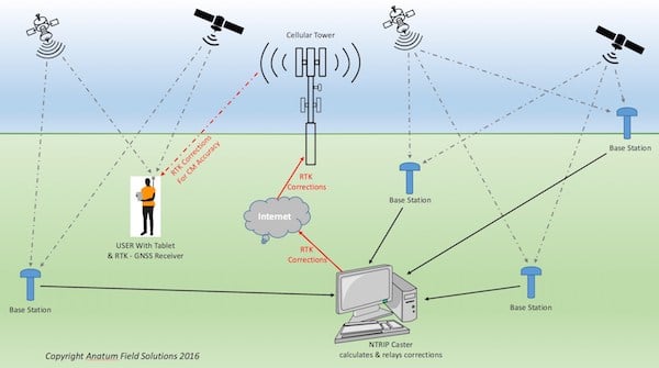
What is NTRIP?
Posted by Tyler on 2/7/2017 to
Adopting Mobile GIS
This article breaks down the explanation of how RTK and NTRIP work to get field users centimeter level accuracy in real-time.

Galileo Satellite Constellation
Posted by AFS on 1/1/2017 to
Knowledge Base
The Galileo system will have all brand new cutting-edge satellites technologically comparable to the U.S. GPS satellites and expectedly more reliable than the Russian Glonass satellites. But the best part is that the Galileo satellites will be able to add more available satellites to receivers capable of tracking more than two constellations simultaneously.
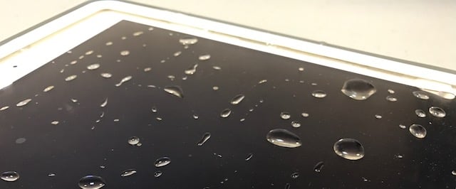
How Waterproof is that Unit?
Posted by Tyler on 12/6/2016 to
Knowledge Base
One of the first couple questions users often ask about tablets, lasers, or GNSS receivers is how waterproof it is, especially those in the Pacific Northwest! This breaks down the different waterproof ratings.
RTK GPS Explained
Posted by Matt on 10/16/2016 to
Knowledge Base
RTK GPS receivers are traditionally very expensive and their accuracy has been thought of as beyond the field mapping needs of most environmental and engineering firms, and government land management groups. However, with the introduction of Bluetooth RTK receivers for use with field tablets and mobile GIS, RTK’s potential has become less expensive to achieve and much desired. Add to that the availability of Bluetooth RTK receiver rentals from Anatum Field Solutions, and the continued progression of many companies into mobile GIS workflows with tablets becomes much easier and more affordable.
RTK Setup with Eos Arrow 200 and Arrow Gold for iOS
Posted by AFS on 5/3/2016 to
Tutorial Videos
Video tutorial for setting up RTK corrections with the Arrow 200 and Arrow Gold for iOS.
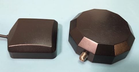
Mobile GIS: What to do with a GPS Antenna?
Posted by Matt on 3/17/2016 to
Adopting Mobile GIS
One of the things professionals have to get used to when they switch from submeter handheld GNSS equipment to mobile GIS workflows with submeter GNSS receivers is their antenna. The important thing to keep in mind is the antenna needs to “see” as much sky as possible and preferably at all times. Below we present a few methods for working with the external antennas used with Bluetooth GPS and GNSS receivers.
