
Posted by Tyler on 2/7/2017 to
Adopting Mobile GIS
Introduction
RTK (Real-Time Kinematic) positioning is a method used by an RTK-enabled GPS receiver to obtain extremely precise positions by using data from an RTK base station (a second GPS receiver) that is transmitted over the internet. The NTRIP protocol (Networked Transport of RTCM via Internet Protocol) enables the mobile RTK GPS receiver (rover) to access data from the RTK base station over the internet to achieve 1cm accuracy.
To explain further, RTK works by having the RTK base station set up at a known geospatial location. The RTK base station receiver is set to the known latitude/longitude/height of this point during setup. The base receiver continuously observes the satellites and calculates position corrections that are sent to the mobile receiver (rover) once every second in a data stream. I’ll refer to it as “base data” in this article. The rover uses location information from the satellites and the base correctional data to compute a precise coordinate.
How are the corrections sent to the rover from the base?
Historically, before mobile devices were so well-connected to the internet, base data was sent via 900MHz, VHF or UHF radios. This meant that the base receiver had to be connected to a radio capable of transmitting and the rover had to be connected to a radio capable of receiving. This system can be expensive, complex, and has limitations. For example, radio signals can be blocked by hills, buildings, trees, etc. The radio signals also have a limited distance they can travel.
In 2004, a German organization by the name of Bundesamt für Kartographie und Geodäsie (BKG) (Federal Agency for Cartography and Geodesy) released the NTRIP protocol. NTRIP provides a method for sending and receiving GNSS base data over the internet versus using 900MHz, VHF or UHF radios.
The benefits of using NTRIP over radio setups:
- Less equipment to carry in the field. Almost all data collectors, smartphones, and computers have the capability to connect to the internet even in a field setting. This is usually done through a SIM card.
- No license required (some radios require licensing).
- Mitigate the chance of radio interference.
- No limitation on communication range. 900MHz, VHF, and UHF radios have a limited range.
The limits of using NTRIP:
- Requires the work area is in range of cellular service for receiving corrections data via the Internet.
How does NTRIP work?
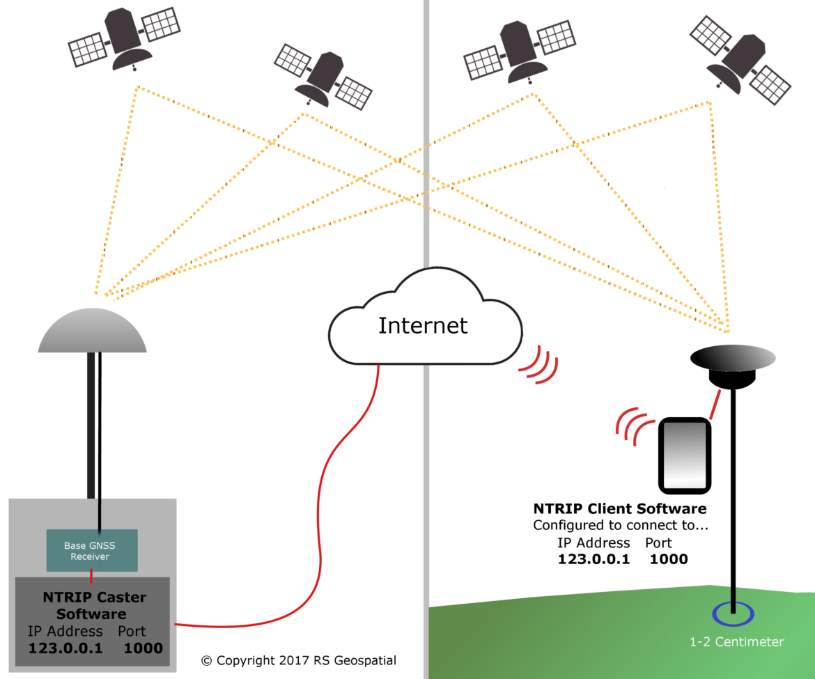
NTRIP consists of two pieces of software which communicate over the internet. The server side runs NTRIP Caster software. The rover side runs the NTRIP Client software. The NTRIP caster is responsible for receiving the data stream from the base receiver and rebroadcasting it over a specified TCP (Transmission Control Protocol) port.
Let’s say that a caster is configured to broadcast over TCP port 1000 and the external IP address of the computer running the caster software is 123.0.0.1. On the rover side, the NRTIP client software is told to connect to the server at IP address 123.0.0.1 on port 1000. This is usually done by the user in a simple form which makes it easy to change servers easily. Once the NTRIP client connects to the NTRIP caster the data stream is sent to the rover receiver via serial, Bluetooth, USB, etc.
NTRIP Services
In most cases, users don’t own/operate an RTK base station. Instead, they request access (paid or free) to an NTRIP service. Many US states operate and run an RTK Network (a network of RTK base stations) and offer an NTRIP service. Access to most public (government-owned/operated) RTK Networks is free. If you want to know which US states offer free RTK Network NTRIP services, refer to this article by GPS world.
What do the Internet and high-precision GPS receivers have in common?
NTRIP has enabled a new generation of users to freely collect centimeter-accurate GPS positional data. In years past, setting up and operating an RTK base station was an expensive and complex task. With the advent of NTRIP, improved internet coverage and smaller/faster/cheaper RTK GPS receivers, centimeter-accurate GPS data collection (horizontal and vertical) technology are no longer only for surveyors and engineers any longer. With the continued growth of public RTK Networks, the technology has become simple enough that it is just another tool in a field technician’s toolbox. This technology has lead to an astronomical increase in adoption of RTK GPS use by engineering and environmental consulting firms, especially for Army Corps wetland delineation work.
Tagged Products
