This has been a great year for the introduction of mobile technology for field use to many companies and government agencies. In 2014, ANATUM helped multiple groups choose a mobile GIS software for field surveys, supplied them with our field iPad rentals, or assembled customized field iPad solutions and external GPS/GNSS for their purchase. We also attended a few events geared at new technologies for field work, including the Emerging Technologies in Field Data Collection Workshop hosted by the Pacific Northwest Aquatic Monitoring Partnership. This was a great opportunity to see how many different groups of biologists had initiated their pilot year with mobile GIS technology. All of the power points from the lighting talks are available at their website HERE.
All in all, it has been a great year, and we are excited for 2015!
We wanted to start off our first blog of the year with a short discussion on the differences between spatial ACCURACY and PRECISION.
Regardless of the industry or field of study, the terms accuracy and precision are thrown around and used interchangeably by some. When working with spatial data, it is important to have a firm grasp of accuracy compared to precision. To this end, ANATUM will soon publish a blogpost comparing the accuracy and precision of multiple GPS devices. So it will be good to discuss these terms here and now.
Accuracy
How close a measurement is to the correct value.
Precision
The consistency of repeated measurements.

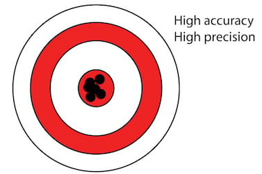
This is a great depiction of the differences between accuracy and precision. For collecting GNSS points, high accuracy with low precision is desirable over low accuracy and high precision.
But obviously, the best would be high accuracy with high precision or very consistent location measurements.
Specifically, the way accuracy and precision relate to surveying has been described with great videos created by the National Oceanic and Atmospheric Administration (NOAA). This video is a great description of these two terms.
We really like that video, and here is another by NOAA explaining Geodetic Datums.
https://www.youtube.com/watch?v=kXTHaMY3cVk
Tagged Products